From the time that Robert Louis Stevenson spent in Napa county and especially Calistoga, a lot has change and some has not. Mount Saint Helena still stands, and you can still follow in some of the footsteps of the famed Scottish author. Starting with just 200 acres in early 1944, this land was obtained to secure a piece of California history for all to visit.
Weather Forecast For Calistoga, CA:
Quick Information:
* Address: CA-29
Calistoga, CA 94515
* Phone: 707-942-4575
* Park Hours: Sunrise to Sunset
* Established: 1944
* Size: 5,272 Acres
* Elevation: Approx. 2044 feet
Day Use Fee:
FREE
Dogs:
No
Potable Water:
No
Toilets:
No
Robert Louis Stevenson in Calistoga:
After spending time meeting and getting to know the locals, the couple made their way over to the Schramberg estate. Enjoying the wine cave and the many, many variety of wine offered by their friend Jacob Schram. You can see the California State Historical Marker #561 located at the Schramberg Winery.
As their funds began to wind down, Robert and his new wife Fanny relocated to an abandoned mining camp on the side of Mount Saint Helena called Silverado, per the recommendations of locals. At the time when he was there though the mine was no longer in operation but it hadn't been long before 1880 (when he and Fanny were there) there had been a town of roughly 1,000 people. It had a Main St., homes and businesses just like any other mining town.
At about 1 mile in on the trail, you will come across what is left of the ruins of the "cabin" where he and his bride set up camp. In the year 1911 the Club Women of Napa County erected a marker in the shape of a book in order to preserve the location. The basics were all they could get up there, so they made due with a cabin of sorts and a bed of straw. For the outside they created a place to relax out of mine tailings.

What Can I Do At Robert Louis Stevenson State Park?
Mount Maint Helena is located in the Mayacama Mountain range which is in total 52 miles long. The total height of this mountain 4,342 above sea level, so there is occasionally snow during the winter months. Most of the trails in the Robert Louis Stevenson State Park are listed as moderate to hard in their difficulty. But if you have the ability to hike to the summit, the views are breathtaking.
There are multiple miles of trails within the state park, ranging from 3 miles to nearly 20. Nearly all trails are designated for foot traffic only but there is another trail designated as bike that begin outside the park boundaries.
Keep in mind that this in an "unimproved" state park. As in there are no restrooms, no water on site and no trash service. Also, dogs are not allowed in this park.
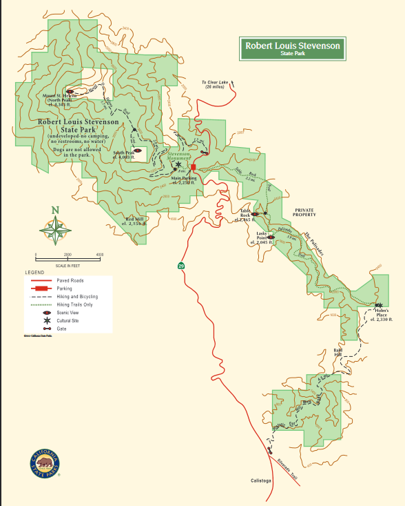
Robert Louis Stevenson State Park Map:


Oat Hill Mine Trail:
The trailhead is located on HWY 29 just past Silverado Tail and Lake street if you are heading North. It's approximately 14 miles out and back and has an elevation gain of 2,417 feet. It's rated as moderate but from the reviews many folks thought it was a moderate+.
Even though the State Park says no dogs, it appears that loads of folks do indeed bring their 4-legged friend along. Just be sure to pick up after your pet if you decide to bring them.
From this trail you can see what is left of a homestead that belonged to Karl Gustav Holm during the late 1800's. There is so much history in Napa and Lake Counties.

Mount Saint Helena Trail:

The trailhead for this hike is on the top of HWY 29 heading out of Calistoga, just past the switchbacks. The trail is 9.3 miles out and back, and most people said this one would be a moderate hike. After you get through the forest and the single track trail, it opens up to a fire road all the way to the summit.

Table Rock:

The trailhead is located on the other side of HWY 29, across from the trailhead to Mt. St. Helena peak. It is 4.4 miles out and back and most considered this one a difficult trail, with little maintenance a little ways in.

Table Rock to Palisade to Oat Hill Mine Trail:
A distance of roughly 20 miles out and back, this trail has the notoriety of being a difficult trail to hike but totally worth the scenery. The trail head begins at the top of 29 just the same as the Table Rock Trail, but it continues onto the Palasades and down to Oat Hill Mine...then back if you are up to it.
A few folks noted that the trail can be a bit confusing, so be sure to upload a map of the hike through Alltrails before going. If you do the return hike, be prepared for an intense gain in elevation as you are going from the bottom of the mountain all the way back up to the top. Bring loads of water!

Bay Area Ridge Trail/Robert Louis Stevenson/Lower Oat Hill Mine:
This trail begins at the bottom of the mountain in the same spot as the Oat Hill Mine trail. It is considered a difficult and technical trail for mountain bikes. It is about 8.6 miles and has an elevation gain of 1,925

Stevenson Memorial Trail:
The Stevens Memorial Trail is a short jaunt from the trail head at the parking lot on HWY 29 in the Robert Louis Stevenson SP. It's approximately 3 miles in total, and it takes you to the memorial that was dedicated in 1911 and on past the remains of the Silverado Mine. It is a high trafficked trail, and it's listed as moderate.

What's Nearby?
This park lies on Mount Saint Helena, just above Calistoga, the town of St. Helena and its neighboring town of Napa. It is also in proximity to Bothe-Napa Valley State Park, which has a campground with cabins and yurts and the historic Bale Gristmill. There are plenty of Bed and Breakfast, Inns and Wineries that offer a great place to stay and just enjoy yourself after a nice day hike.
Helpful Resources:
Though we didn't hike Robert Louis Stevenson State Park, we have passed by it numerous times on our way over HWY 29. I learned a lot about it during my research, and I found it quite interesting in its history. Plus the photos I saw were stunning, it looks like a hike that is worth the view alone.