The South Yuba River State Park is comprised of 7 different locations along the Southern portion of the Yuba River. It encompasses 11,000 acres in total with 2,000 of those acres being managed by California State Parks.
The options for recreation are diverse within this park. Rafting, swimming, hiking, bird and nature observation and gold panning. The only thing that isn't included in this is a campground. There are not any within this park system.
Weather Forecast For Nevada City, CA:
Quick Information:
* Address: 17660 Pleasant Valley Rd Penn Valley, Ca 95946
* Phone: (530)432-2546
* Park Hours: Sunrise to Sunset
* Established: 1997
* Size: 11000 Acres
* Elevation: Approx. 1,350 feet
Day Use Fee:
$10 per vehicle
Dogs:
Allowed on leash in parking lot only.
Potable Water:
No
Toilets:
Yes, flush, pit and portable
South Yuba River State Park Area:
The South Yuba River State Park is comprised of 7 different locations along the Southern portion of the Yuba River. It encompasses 11,000 acres in total with 2,000 of those acres being managed by California State Parks.
State Park Maps:

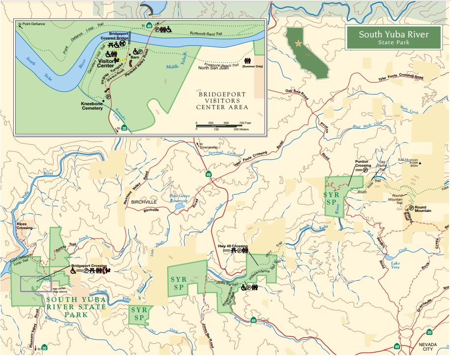
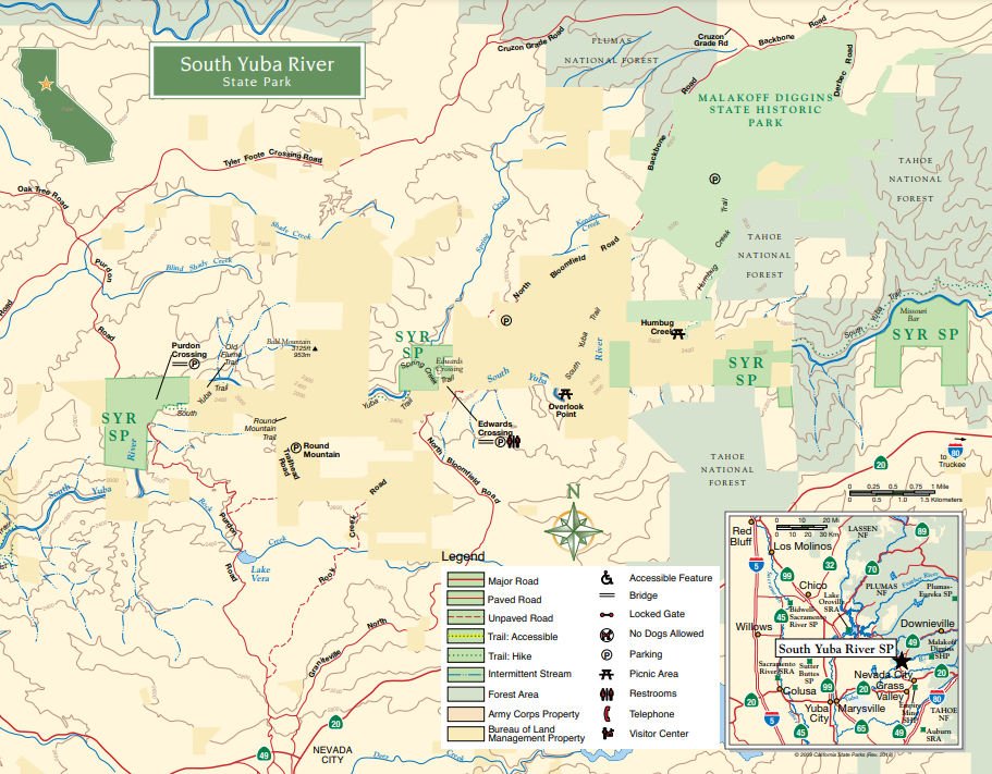
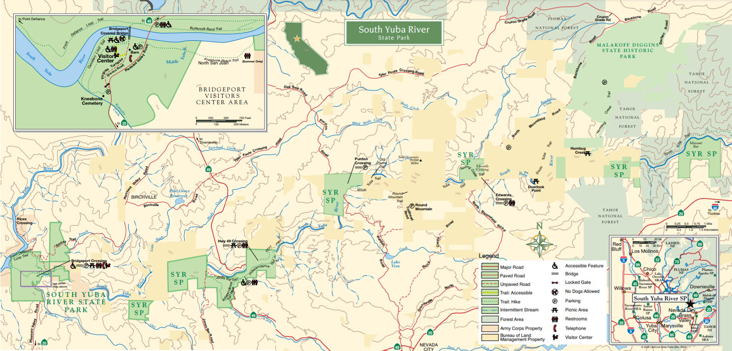
South Yuba River State Park Map (Eastern Side)

South Yuba River State Park Map (Western Side)

South Yuba River State Park Map (Full)
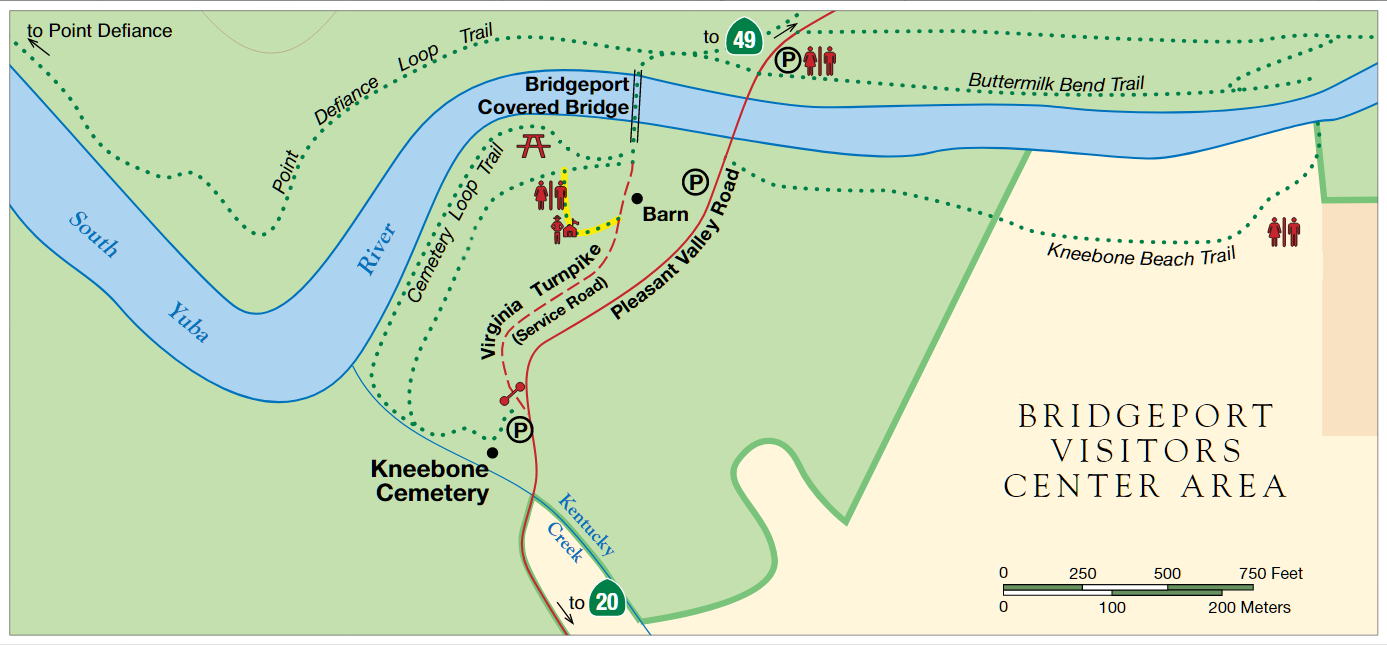
Bridgeport:
The Bridgeport area of the South Yuba State Park is a great place for families to enjoy. It has a few nice and easy trails, beautiful beaches with amazing swimming areas and well-preserved and documented history.
Hwy. 49 Crossing:
One of, and if not possibly the most popular destination for swimming in the South Yuba River State Park designation.
This area is known for swimming!
Edwards Crossing:
Edwards Crossing is a great place to go swimming and has a couple of trails that you can hike as well.
Most of the people that come to Edwards Crossing will usually come down there to swim on the South Yuba River and some people even choose to camp here, on the 4 1/2 mile stretch between Edwards Crossing and Purdon Crossing, which does allow camping.
Purdons Crossing:
Purdons Crossing is a lot like Edwards Crossing, where you have the river to swim in but only has one main trail and that trail is actually the trail that leads to Edwards Crossing.
A lot of people that come to Purdons Crossing will either visit to go swimming at the river or camp in that same four and a half mile stretch, along the South Yuba River.
Missouri Bar:
Missouri Bar is probably one of the least favorite areas when we talked about the South Yuba River State Park because there is really only hiking trails around the area and a lot of the trails are very difficult for most people to do because they are steep, narrow, not very well maintained and have a lot of other challenging aspects to them like massive amounts of poison oak, gnats, mosquitoes Etc.
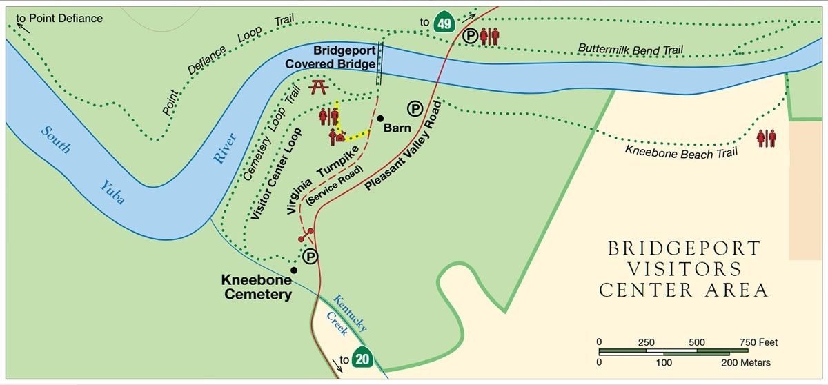
Bridgeport:
Bridgeport is probably the most visited and popular area in the South Yuba River State Park that people visit because of the covered bridge, all of the other historical buildings in the area and because the river access is very easy and convenient for most people, even if you have young children.
The river in this area is wider and more slow flowing in the summer months, making it an ideal place to go swimming with the family.

Here is an area where you can include any pictures of the area if you want to include, a map would work well for the specific area and not the same app that we already saw for the entire state park area.
You can use this section if you need more space for what you were talking about, otherwise you can delete this and somehow make the above paragraph you wrote work with your image or images.
Historical Aspects:
Bridgeport has many historical aspects to the area, mainly from the time frame of around the 1860s to the 1930s, and has many of the structures that were around in those days still standing on their own or with the help of a little bit of rehabilitation.
The Covered Bridge:

The bridge is truly one of a kind as it is the longest spanning covered bridge in the world. Built in mid 1861 the Bridgeport Bridge was originally a toll bridge for commodities carried to mines as far a Nevada. Toll prices ranged from $.05 cents to $6. At that time the $1 would be worth at least $30 in todays time.
Over the years the bridge has seen damage from major rain storms which rose the Yuba River to bridge deck to neglect and nearly being condemned. Thanks to places like the Nevada County Historical Society among others, this bridge was saved for us to enjoy today.
At the time of this writing the Bridge has been closed to the public since 2011 as it was deemed unsafe. We are hoping that this year after the extensive restoration 10 years later that it will be open again.
The Barn:

The barn you see today was built right about the same time as the covered bridge, right about 1861. Its was used as a lay over of sorts. Teamsters and their animals could stay over before carrying on, getting food, water and rest.
The barn is situated perfectly so that the teams of horse, mule or ox would not need to turn around. The barn is lined up just so that it faces the bridge entrance perfectly which would make it simple for the teams to pull through after their resting and filling up.
Gas Station:

During the time when the Kneebones owned and operated "Kneebone's Bridgeport Pleasure Resort" they had the gas station installed. This happened around 1927 and ran all the way till about 1944. You could also rent cabins and enjoy the dance pavilion and dining hall. They were located about 1/4 mile up river near the swimming hole, down from the Buttermilk Bend Trail.
Right behind the gas station you will see the store. This supplied guests and passing motorists with with groceries including ice cream, beer and food. To the left of the store and gas station you can see the door to the cold storage room. They stored ice in there along with the perishables.
The resort was run till some time in the 1930's when hydraulic mining started up again which turned the rivers and waterways brown and silty. The resort went out of business but the gas station remained open until the 1940's.The gas station is fully refurbished with many thanks to the South Yuba River Park Association.
Kneebone Cemetery:

The Kneebone Cemetery is the family cemetery for the first settlers of the Bridgeport area. With burials ranging from 1853 to 1991 there are only 9 plots with 11 burials.
Visitor Center:

The Bridgeport Visitors Center was built in 1997 as a place to give visitors an overview of the historical grounds they were spending time on. There you can find books, maps and fascinating information. This place is generally run by volunteers who have a love for this historic park.
During the summer, volunteer docents hold gold panning demonstrations, flower walks and other enjoyable group activities.

Vehicles:
Bridgeport has excellent options for parking on both sides of the park. In the main area of the park, (covered bridge area) there is parking right near the covered bridge and barn. Parking here is $10 for the day. Across the river, on the opposite side of the main day use area, is additional parking which is also $10. This lot has a state park booth of sorts where you can pay your fee and ask any questions about the park.
There is free parking in smaller areas alongside the road, but note that it can be a pretty busy road and there is really not a lot of parking options, especially when the park is busy.

Bathrooms:
There are three different bathroom locations at Bridgeport and these are located at the parking and fee area, where the Buttermilk Bend Trail starts, behind the visitor's center and at Kneebone Beach.
The bathroom at the visitor's center is equipped with flushing toilets and are preferred by most people who visit. The parking area (Buttermilk Bend Trail entrance) has a pit toilet and Kneebone Beach Trail has portable toilets that are brought in for the summer months only.

Dogs:
Dogs are allowed at most areas within the South Yuba River State Park area as a whole, with a few exceptions that really affect the Bridgeport area. Dogs are not allowed on the "family beach" area or 200 feet down stream of that area.
To sum that up, no dogs are allowed at the beach area that is right by the covered bridge or 200 feet down stream, but are allowed everywhere else. It didn't say anything about a leash on the state park website, but I would bring one, just in case.
Trails:
There are five main trails in the Bridgeport area of the SYRSP and 4 out of the 5 are relatively easy for most people of all fitness levels. The defiance loop trail is the hardest trail by-far and is a more strenuous trail for more serious hikers.

Buttermilk Bend Trail:
The Buttermilk Bend Trail is a really easy 2.4 mile trail out and back. Located out of the farther parking lot, it's great for families too and its pretty stroller friendly with plenty of turn outs so people can pass you. There are a couple of uphill areas but they are really minimal.
This trail offers amazing views of the Yuba River. If you are sans kids or you have kids who can rock scramble, then this trail have some offshoots that can get you down to some nice swimming spots that aren't crowded.
During the early spring time there is an abundance of wildflowers and butterflies along this trail with plenty of benches along the way to take in the view. This is also a dog friendly trail as long as dogs are kept on leash and of course, you pick up after them.
Kneebone Beach Trail:

The Kneebone Beach Trail is the access trail down to one of the more popular swimming holes at Bridgeport. It is located on the south side of Pleasant Valley Road adjacent to the parking lot at the covered bridge and it runs paralelle to Pleasant Valley Road. This was originally where the Kneebones Bridgeport Pleasure Resort cabins were located. The trail is approximately 0.3 miles long, just a short jaunt.
Cemetery Loop Trail:

The Cemetery Loop Trail begins at the Kneebone's Gas Station on the now historical Virginia Turnpike, heading towards the cemetery. The loop then turns and heads towards the river and basically taking you to family beach and back out to the visitors center. It's a very easy hike as we did it with 3 little kids, its about .6 miles.
The Virginia Turnpike: The Virginia Turnpike (where the trail begins) was at one point used by 100 plus wagons a day, many of them on their way to Nevada.
The rock walls alongside of this road that you will travel on to get to the cemetery were built to keep wagons and the like contained and headed towards the Bridgeport Toll Bridge.

Visitor's Center Loop:
The Visitors Center Loop is pretty much the same as the Cemetery Loop except its shorter and takes an inner circle. It begins and ends at the Visitors Center with a walk through the Virginia Turnpike. This short trail is 0.2 miles.
Point Defiance Loop Trail:

This loop trail is approximately 2.9 miles and is considered a moderate hike due to the switchbacks. Most people recommend starting with the switchbacks instead of ending the trail with them.
This may not be the best trail for small children if you plan on making the loop. If you want to take an easy hike then it is recommended to hike from Bridgeport along the river to Lake Englebright and back the same way you came. It can be a bit narrow in places but its an overall really nice trail.
The trail is accessed on the far side of the covered bridge (opposite of the parking lot near the barn). This trail takes you down to where the South Fork of the Yuba and the Middle Fork meet at Lake Englebright.
Hwy 49 Crossing:

The old Highway 49 bridge at Hoyt's trailhead was built in 1921. It was closed to vehicle traffic in 1994 when the new bridge was built. You can now park at the bridge entrance if you get there early enough.
This is the most popular destination for the Yuba River, as its proximity to the Independence Trail and Hoyt's Crossing Trail. This bridge is a great place to come especially during the rainy season. You can watch the high water running fast and often times you can hear boulders being moved in the raging water.

River:
The River area located at the highway 49 Crossing portion of the South Yuba River State Park is probably the best area to go swimming in the South Yuba River because of the ample amount of parking, compared to the other areas and has many great riverfront spots that have small beaches, not too far from where you park.
Trails:
There are two main trails located near the highway 49 Crossing portion of the South Yuba River State Park and these are the Independence Trail and the Hoyt Trail.
The Independence Trail is a much larger trail and splits off in two different directions, whereas the Hoyt Trail is a shorter trail that leads you three quarters of a mile upstream of the main swimming beach, where most people swim but be aware that this area is known for its "clothing optional" crowd and is what you will typically find here.
Independence Trail:

Once a flume that carried water for Hydraulic mining, upon completion the Independence trail was the first of its kind being hailed as the first in the nation for handicapped accessible wilderness trail. There are 2 directions to this trail, East and West.
The West side of the trail is amazing and has been one of my favorite places to walk for decades. This trail walks along the restored flumes and over Rush Creek. There is a handicapped accessible ramp leading down to a nice view of the waterfalls and pool of Rush Creek. Beyond this though the trail hasn't been maintained so it is no longer wheelchair accessible. By foot though you can still take it all the way to Jones Bar Rd and down to the river.
The East side is also a nice trail with some great views. I have seen clusters of salamanders mating in the waters along side the trail, so there is wildlife to be seen.
Sadly though the Independence Trail sustained major damage in the summer of 2020 during the Jones Bar Fire. It is unknown if and when this trail will reopen.
Hoyt's Trail:


This short trail is .75 miles long and runs along the left side of the South Yuba River Old Hwy 49 bridge. You will see the stairs leading up to the trail. Its a heavily used trail and dogs are allowed on leash. If you don't want to make it to the nude beach there are off-shoot trails down to over swimming areas. Not necessailty "beaches" but places that you can swim from.
Edwards Crossing:
Edwards Crossing has some historical significance as far as the bridge is concerned and a little ways up stream you can find Illinois Bar, which used to be the site of a ferry crossing before the bridge was built.
There is really nothing else here besides swimming areas along the river and a couple of trails that are moderately difficult, due to the fact that they run along the river, in line with the terrain of the surrounding area.
The Bridge:

Named for a Mr. William Edwards, this bridge dates back to 1904. Although this bridge didn't exist during the time of Edwards it is named after him as he was the last owner of this piece of land. He was originally ferried folks across the river at the now lost Illinois Crossing which was located upstream.
River:
The South Yuba River runs under Edwards Crossing and here you can find many different swimming holes, where the water slows down quite a bit and it actually gets quite deep in a few areas.
You can hike up the South Yuba River a little ways and that's where you will find Illinois Bar Crossing, where a ferry would carry people and their commodities across before there was ever a bridge constructed in the area.
Trails:
There are two different trails in the area, and they both run along the South Yuba River. Both trails are moderate hikes due to the steep terrain and the large rocks in the area, so it is not really kid friendly, especially if you have younger children with you.
Edwards Crossing To Purdons Crossing:

The main trail at Edwards Crossing is the Edwards Crossing to Purdon Crossing Trail, which like the name states, connects the two areas, via a trail that runs along the South Yuba River. This is a pretty long trail, coming in at around four and a half miles one way, and is a moderately difficult trail because of the terrain.
Spring Creek Trail:

Purdons Crossing:

Purdons Crossing is another area that has historical significance, as far as the bridge goes, along with the area itself as well. There's only one main trail at Purdons Crossing about the river area and swimming holes that are here are very nice and you're really the main reason people come down here.
You can camp along the river in between Purdons Crossing and Edwards Crossing, along that four and a half mile stretch, which is what a lot of people do and makes for a unique experience.
The Bridge:

With a total length of 191.9 feet long and 13.1 feet wide the Purdon Crossing Bridge is dated back to 1889 and is said to have been built my the Cotton Brothers. This bridge is the only of still in use as an original Pratt half through truss. The Pratt truss was invented in 1844. The Purdon Bridge is listed as Historic Place per the National Register of Historical Places.
River:
Most people that come down to Purdons Crossing to swim or camp along the river will usually travel Upstream in most cases, which is where the Edwards to Purdons trail is located.
Heading upstream is also where that 4 and 1/2 mile stretch of the river is between Edwards Crossing and Purdons Crossing that you can camp along, so it makes sense that most people head in that direction when they come down to the river.
Trails:
There's only one trail at Purdons Crossing that is used and that takes you to Edwards Crossing. It runs along the river, along the southern side. It is a clearly marked trail, for the most part, and moderately to heavily travelled.
Purdons Crossing To Edwards Crossing:
This is the same trail I already talked about in the above section I wrote about (Edwards Crossing) and is roughly 4.5 miles long, one way. It takes most people a couple of hours to walk the entire trail, one way.
Missouri Bar:
There is some conflicting information on the Missouri Bar Trail. It seems to be under the care of the Tahoe National Forest so there isn't any information on the State Park website and little information on the internet.
It seems that the trailhead is located at the South Yuba River Campground which is a BLM campground. This is located across Edwards Crossing bridge and about .4 mile up the hill on the dirt road. There you will see the campground sign.
From my research this trail is used a lot by mountain bicycalists.

Helpful Resources:
There we're quite a few resources I found along the way while doing research on the South Yuba River State Park and I listed some of the most helpful ones below, for those of you out there that may want to take a look at those resources too.
I also posted the maps I found and made below all in one area, so you can scan through them easily, instead of having to go back and read through the post in order to find the specific map you want to look at.